A landslide that occurred in 2024 along NH-44 (Image by Hirra Azmat)
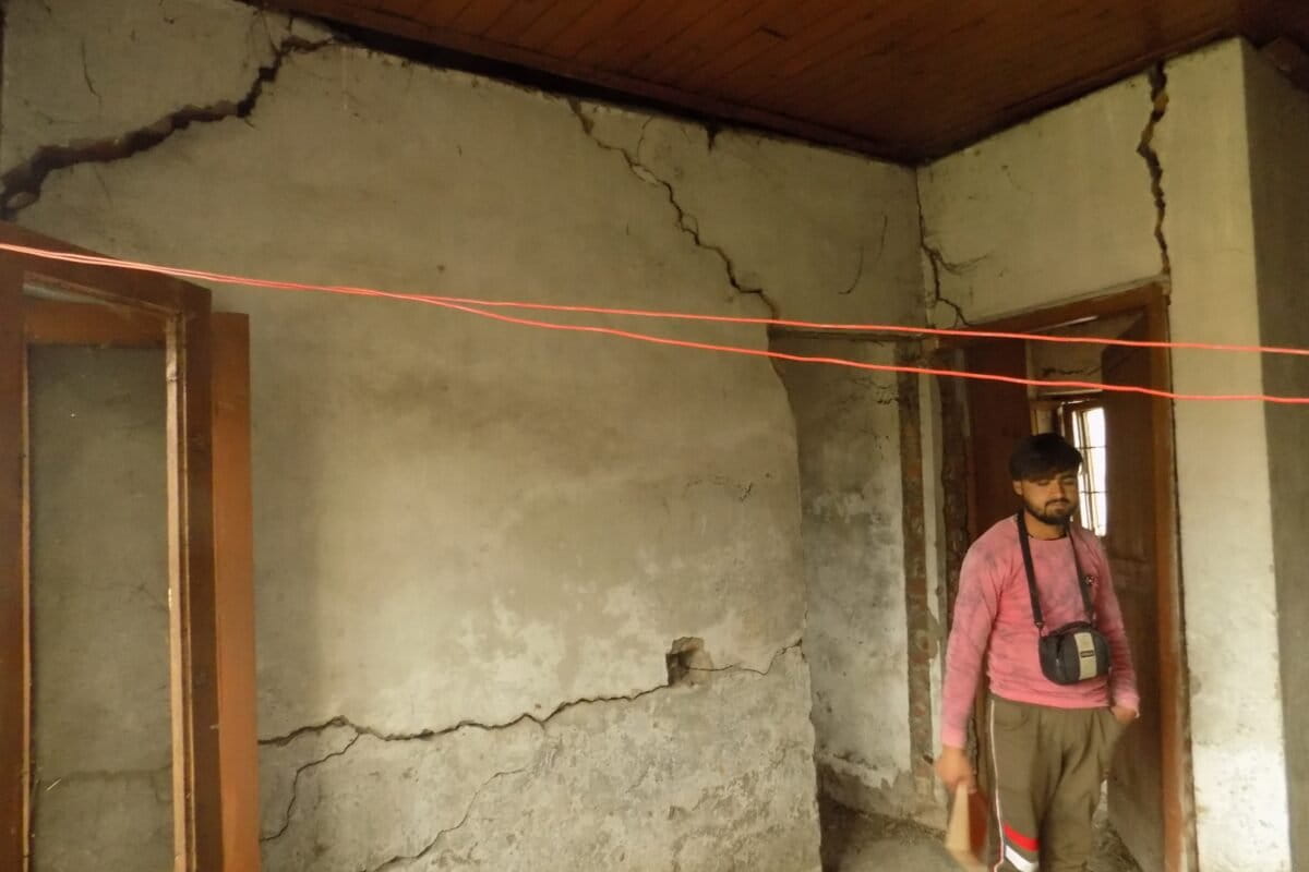
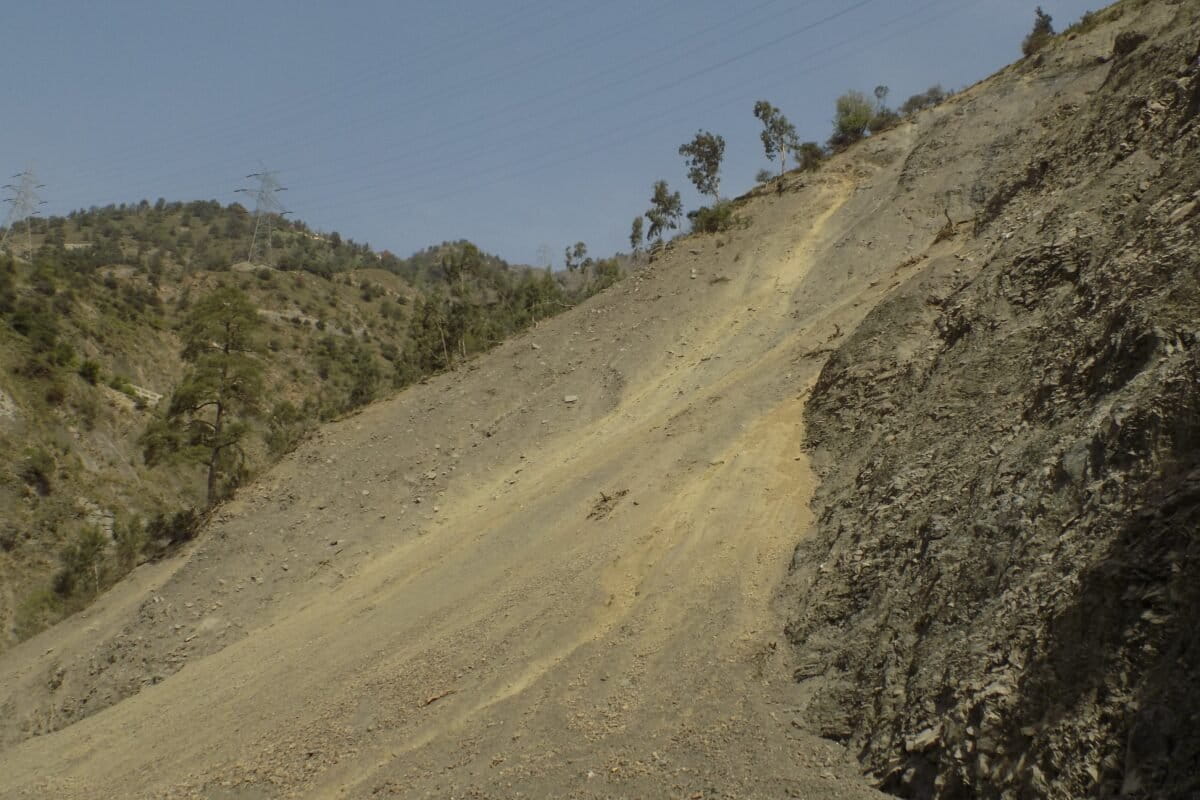
The Srinagar-Jammu National Highway (NH-44), the region’s main arterial road which runs from Jawahar Tunnel Banihal to Ramban in the Kashmir Himalayas, is among the most landslide-prone roads in the Himalayas. Weak rocks and steep slopes that crumble easily under heavy rainfall make the highway particularly fragile. A new study assesses the slope stability of various road cut slopes along NH-44 and identifies slopes ranging from moderately stable to unstable, which are prone to instability and collapse.
Cutting across the Pir Panjal range of the North-Western Himalayas, the NH-44 passes through mountains that are “young, fragile, and highly fractured,” says Mahjoor Lone, an earth scientist at Northumbria University. “The rocks are weak, full of cracks, and often oriented in ways that make large blocks prone to sliding out once the slopes are cut. Road construction has further left behind steep walls, and when heavy rainfall seeps into the cracks, the rocks lose strength and collapse. This natural fragility makes the highway highly prone to landslides.” Lone explains. The study also notes that the region lies within a tectonically active zone, making the slopes inherently unstable.
Data shows that between 1990 and 2020, around 960 landslide events were recorded along NH-44, killing 1,000 people and injuring 267 others. Moreover, of the region’s 20 districts, 16 face relatively high landslide risk and suffer related social and economic damage.
The new study published in the journal Applied Geomatics in June this year, examined 27 road cut slopes for strength through rock mass rating (RMR) and slope mass rating (SMR), and conducted kinematic analyses at 48 sites.
“The first step to assess slope stability was to measure the rock mass quality using RMR and SMR, which are standard methods to judge how strong or weak a rock slope is,” says Riyaz Mir, Scientist C at the National Institute of Hydrology, Western Himalayan Regional Centre, Jammu, and a corresponding author of the study. “We then carried out kinematic analysis to see how the cracks, joints, and layering in rocks could lead to different types of failures such as sliding, toppling, or wedge collapse.”
To identify the most vulnerable spots, the researchers divided the highway into four litho-structural domains (D1 to D4) based on rock type and structure. At dozens of sites, detailed field surveys, mapping, and measurements were carried out. Weak zones, such as slopes made of soft rocks like slates, phyllite, or weathered gneiss, with poor drainage or unfavourable rock joints, were marked as high-risk areas. “This combination of rating systems, field surveys, and structural analysis helped identify the most unstable locations, where landslides or rockfalls are most likely to occur,” Mir notes.
Mir highlighted that compared to highways in Himachal Pradesh and Uttarakhand, NH-44 faces slope failures more often and with greater intensity, especially during the rainy season.
“The problem is made worse by ongoing road widening works and heavy traffic,” he adds. “While roads like NH-7 in Uttarakhand or NH-305 in Himachal are also risky, NH-44 is more dangerous owing to its long unstable zones and its importance as the only all-weather lifeline to the Kashmir Valley.” Mir also notes that some locations such as the Cafeteria Morh near Ramban, remain active landslide zones, where rocks and debris fall throughout the year, even on sunny days. “Overall, the stretch from the Nashri Tunnel to Panthya-Ramsu is highly vulnerable to frequent landslide activity.”
Meanwhile, Lone, who is not associated with the study shares, “It (the study) identifies the most dangerous locations and suggests practical solutions such as re-profiling slopes, rock bolting, and better drainage. This makes it a useful guide for engineers working on ground. Future work should be complemented with climate and hydrological studies, as well as continuous slope monitoring, to offer a complete risk management framework.”
Nadia Mubarak, a senior research fellow at the Department of Earthquake Engineering, IIT Roorkee, also not associated with the study, states that it makes a timely and valuable contribution to understanding landslide hazards along one of the most critical transport corridors in the region. “By combining SMR and kinematic analysis with Geographic Information Systems (GIS)-based mapping, the authors provide a systematic framework for identifying and prioritising unstable slope sections,” she added. “This is particularly important in the Kashmir Himalaya, where fragile lithology, steep gradients, and intense construction activity converge to heighten landslide risks.”
Mubarak also notes that one of the study’s main strengths is its field-based methodology and its focus on generating actionable results for infrastructure planning and mitigation. “By identifying specific slope sections with moderate to high susceptibility, the research offers clear practical implications, allowing engineers and policymakers to target interventions more effectively. However, the methodology does have its limitations.”
Kinematic analysis looks only at the shape of slopes and the way rocks are arranged, but it does not fully capture dynamic triggers such as heavy rainfall, snowmelt, or earthquakes, factors that often cause slope failures in the Himalayas. “Similarly, while the paper highlights the role of anthropogenic drivers such as excavation and road widening, these impacts are not quantified in depth, leaving some uncertainty in separating natural versus human-induced influences,” Mubarak emphasises.
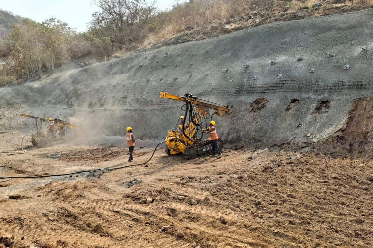
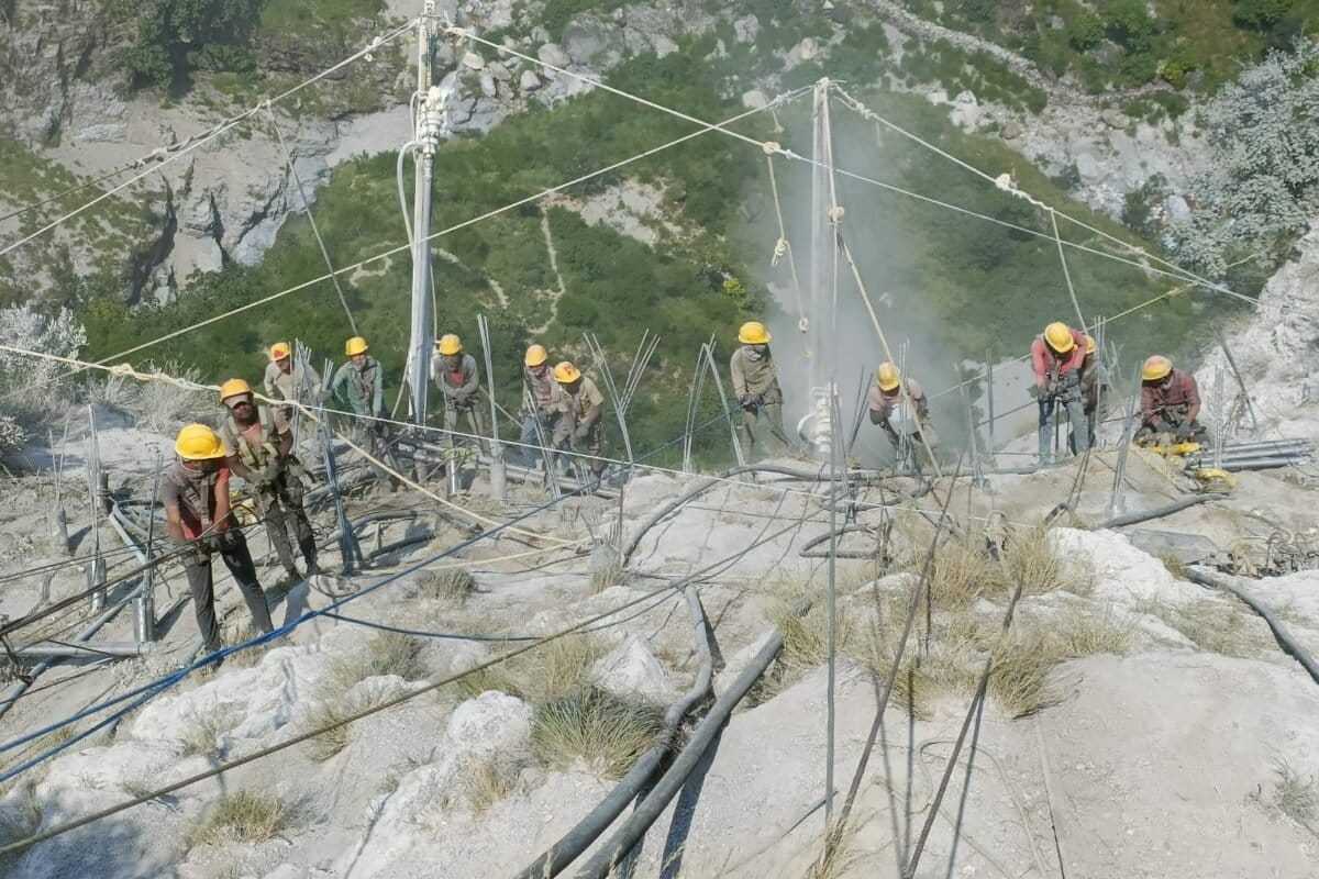
Experts warn that road widening and tunnelling significantly disturb slope stability. Widening makes slopes steeper and more unstable, and blasting during construction creates new cracks in the rocks.
“Careless dumping of debris adds extra weight and blocks natural drainage channels, further destabilising slopes. “Tunnel entrances also weaken the surrounding rocks, which can fail unless immediate support is provided. These activities, if not managed carefully, worsen an already fragile situation.” Lone says.
Mubarak adds that these disturbances have further facilitated enhanced rainfall infiltration, elevated pore-water pressures, and progressive weakening of already fractured and weathered rock masses.
The last two months have been a stark reminder of how climate change is reshaping the Himalayas, with catastrophic events unfolding in Uttarakhand, Jammu and Kashmir, and across the border in Pakistan. In August, cloudbursts, landslides, and flash floods across Kishtwar, Kathua, Reasi, and Ramban districts in Jammu claimed 130 lives. The deluge peaked on August 26-27, when heavy rain triggered flash floods in Jammu and its surrounding plains, damaging infrastructure and houses, leaving thousands homeless and displaced.
“In the Kashmir Himalayas, the impact is particularly visible in the form of rising landslide risks,” Lone says. He added that rainfall patterns have changed. “We are witnessing a shift from steady seasonal rains to sudden cloudbursts and extremely heavy downpours, where a month’s rainfall can occur in just a day or two. Slopes saturated with water quickly lose stability. “Melting glaciers and shrinking snow cover are also altering river flows across the Himalayan regions and, in some cases, triggering sudden floods and slope failures.” Lone further adds that extreme weather events are now occurring more frequently, with shorter gaps between them, giving slopes little time to recover. “All of this adds to the natural fragility of NH-44.”
Working in a tectonically active and landslide-prone region presents persistent challenges for highway engineering. The combination of frequent rainfall, steep and variable topography, and highly fractured rock masses significantly heightens landslide susceptibility, directly affecting road safety, construction costs, and project timelines. Mubarak states that ensuring slope stability requires continuous geotechnical monitoring and adaptive design approaches that can respond to changing ground conditions. “In addition, maintaining reliable connectivity is a major concern, as slope failures often lead to prolonged closures.”
Lone notes that the first step to prevent landslides along the highway is to reshape the dangerous slopes into safer angles rather than leaving them vertical. “Weak slopes must be supported with rock bolts, wire mesh, and concrete spray, with retaining walls where necessary,” he says. “Proper drainage is absolutely critical as both surface and subsurface drains must be built and regularly maintained. Protective barriers such as rockfall nets and catch fences can help keep falling debris off the road.”
He adds that the rain gauges and slope monitoring systems should be installed to provide early warnings, so that authorities can temporarily close the highway when rainfall crosses danger limits. “Future infrastructure development in the Himalayas should also focus on better slope management, combining engineering works with bioengineering methods such as planting deep-rooted vegetation to hold the soil together and prevent erosion.”
The experts further stress that community engagement and public awareness is equally important. People living near the highway should be informed about active landslide zones and safer areas for housing, farming, and development. Mir states that any scientific findings must be shared quickly with local communities so they can plan land use more safely. “The local government authorities should ensure that research and risk information reach people immediately to reduce threats and build resilience.”
A senior official at the National Highways and Infrastructure Development Corporation Limited (NHIDCL), on condition of anonymity, shares that the high-risk stretches of the highway include Panthal, Ramban, Digdol, and Khooni Nallah. The source, also a site engineer, requested anonymity as they were speaking in place of the engineer responsible for this section of the highway, who was unavailable for a comment.
“For slope stabilisation, measures such as rock anchors, self-drilling anchor bars and wire mesh have been installed. Since the rock quality in the area is poor, tunnelling has proven to be the most effective solution for managing landslides. The frequency of such incidents has already reduced significantly due to the tunnel construction,” they add.
(Published under Creative Commons from Mongabay India)
Delhi’s air may be growing more toxic by the day — but on Sunday, authorities appeared to view a peaceful…
The 14th State Level Philatelic Exhibition, MAPPEX-2025, organized by the Madhya Pradesh Postal Circle, was held in Bhopal from November…
South Asia accounts for 50% of the groundwater pumped for irrigation globally. The practice has been critical to ensuring food…
Earlier this week, news came in that ousted Bangladesh Prime Minister Sheikh Hasina has been sentenced to death – by…
At the 14th edition of the Dharamshala International Film Festival, three documentaries stood out for the way they portrayed the…
The Special Intensive Revision of the voters list across 12 Indian states could potentially lead to sharpening of the communal…
This website uses cookies.